Other Services and Example Projects
The Enviro software suite from Geotech Computer Systems brings powerful yet affordable environmental data management and display to your desktop. From planning your sample events to creating tables and maps, professional-grade tools help you save time and money, and improve quality, on your projects. However, sometimes your requirements may not fit into any of the above categories. That's when you need to talk to someone who has enough experience and creativity to structure just the right combination of service and technology to meet your needs. In addition to our industry-leading software. Geotech has successfully completed many client projects with custom and semi-custom software solutions. Below are some examples of projects we have successfully completed using our Enviro software suite paired with other industry standard tools.

USACE FUSRAP Project - LIMS and Data Management System
Geotech provided software for a New Jersey FUSRAP site to manage laboratory analyses and store the results in a database. This included rewriting an outdated Laboratory Information Management System to project specifications, and converting project historical data from a proprietary format to Enviro Data. While most of the Enviro implementations for the Corps involved the use of existing functionality, for some projects we have added functionality in a number of areas, including enhancements to the field planning tool, data selection, and reporting, along with interfaces to laboratory equipment.
Software Interface for USACE FUDSChem System
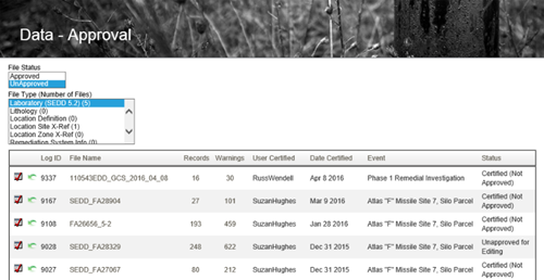
 Geotech's Enviro Data program was the first third-party off-the-shelf software to successfully upload SEDD data to FUDSChem. The Staged Electronic Data Deliverable (SEDD) format was developed jointly by the Army Corps of Engineers (USACE) and the US EPA starting in about 2004. “Staged” means that the format has four levels, each with additional data content. The SEDD 2a format is the most used for laboratory data. It has gone through a number of versions, with the latest version (as of April, 2016) being 5.2.One significant implementation of the SEDD format is for the Formerly Used Defense Sites (FUDS) program for the USACE. The corps has instituted a centralized database for data generated on FUDS projects called FUDSChem. This system, which went online in 2013, includes an import system for ingesting SEDD 2a format files, performing various data checks during import such as data format, property and project information, locations, field lengths, and required content, such as valid value lists (VVLs). FUDSChem integrates with other USACE systems such as FUDSMIS. Once data has been successfully uploaded, it can be queried and displayed in a variety of ways.
Superfund Project - Analysis System for Sample Data
 Geotech designed and implemented a software program for tracking and analysing sample data for a Superfund site for a group of Fortune 500 companies. The resulting system allowed the user to interactively select a sample location or group of locations, select a contaminant parameter or group of parameters, and determine non-compliant analyses within a depth range for surface soil, stream sediments, surface water and groundwater. These analyses could then be displayed on the map as color-coded symbols based on parameter-specific cutoffs. Provisions were also provided for storing and manipulating NAPL (non-aqueous phase liquids) data. Another part of the system managed the display of base map information imported from the AutoCAD drafting program, allowing the user to choose which base map and station data would be displayed, and these elements could be turned on and off to emphasize whatever subset of the data was important for a given map. The cost of developing the system was more than offset (by a factor of five-to-one) through savings on clerical time in preparing maps of contaminant locations.
Graphical Front End for Corporate Data
Geotech was a contractor to a leading computer company, assisting in the design and creation of a graphical front-end to corporate data stores resident on mainframes, UNIX workstations, and personal computers for their petroleum company clients. This system provided a global data dictionary which contained information on data types, formats and locations for both digital and hard-copy data. Geotech’s contribution was to the integration of the map-based selection system with the rest of the SQL-based query system (based on a UNIX version of a subset of our Spase software), and in providing and converting base map data for use in the system

Image Database Project
Geotech performed a project which provided a graphical system for managing images of paleontological specimens collected by a major oil company during offshore oil drilling. The resulting program provided a set of diagrams to assist in the identification of specimens based on images stored in the database. These images were captured using a video camera attached to a binocular microscope or were scanned from the literature. They were then cataloged in a relational data model, and access routines provided to allow the user to subset the data based on the information available. They were then able to view "thumbnails" of the subset specimens, and then select an image for full-scale view. This image on the computer screen could then be compared to the image on the monitor attached to the video camera to aid in the identification of the fossil, which was important in monitoring drilling progress. Similar technology can be used to manage documents, drawings and other images associated with project data.

Petroleum Exploration Corporate Database
Geotech provided a software and service solution to a large independent oil company’s needs for a corporate client-server system for managing petroleum exploration and production data. The resulting system provides up to 20 users with access to the corporate database, and allows them to carve out subsets of the data for project use by making graphical selections on maps on the screen. It uses the Spase spatial database manager as the graphical, map-based front-end, and Oracle on a Banyan server as the central repository. This approach can be used with any kind of data which has a map component, and is essentially unlimited in data capacity, while at the same time providing almost instant access to any data in the system.
Agricultural Landscape Simulation
In cooperation with Terra Spase in Napa, California, Geotech developed a marketing presentation to illustrate the locations of vineyards and distinct soil types for an Appellation (group of vineyards). This project involved acquiring Digital Elevation Model data and culture data (roads, streams, etc.) from the U.S. Geological Survey, digitizing the soil polygons from hard copy maps, and then using surface modelling software to develop realistic-looking mountains with the other data draped over them.
Volume Modeling of Industrial Facility

 In cooperation with Grant Environmental, Inc., Geotech created a three-dimensional model of the values of two radioactive contaminants at an industrial site in the Midwest. Starting with about a thousand borings and several hundred thousand measurements, we used geostatistical software to prepare a map and cross section to estimate values in 330,000 three-dimensional blocks. The results of this analysis were used to estimate the volumes of soil at different contamination levels and to generate graphical displays of the contaminant distribution in preparation for site excavation.
Visual Impact Study
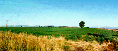
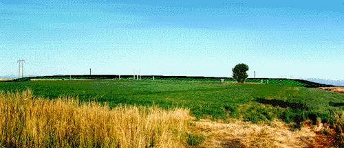
Another interesting Geotech project was a visual impact study performed for a client to determine the visual impact of different configurations of a landfill design. Geotech photographed the site from several vantage points with 60” balloons at several elevations above three locations at the site. Then the Surfer contouring program and the Corel Draw graphics program were used to create three-dimensional representations of the different configurations and superimpose them over the site photographs. This allowed the client to better understand the impact of their plans on the mountain views of their neighbors, and to document that for most of the people the impact of the proposed configuration would be minimal.
Corporate Environmental Data System
Geotech performed a project for a Fortune 500 industrial company to evaluate and satisfy their environmental data management needs for a division of about 80 people. The first stage was to use an interview process to perform a needs assessment. The second was to use the resulting needs to design and build a data management system using Microsoft Access as a front end and Microsoft SQLServer as a back end for storing several million records of environmental site investigation and remediation data. This system integrated data gathered in the field and in the laboratory, and provided both textual and graphical output, including interactive map displays using the SylvanMaps OCX technology.
Web-based Weather Mapping System
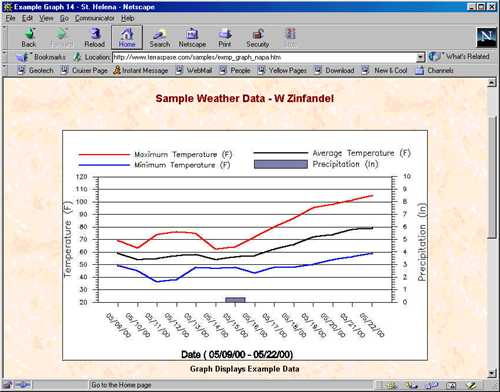
Geotech cooperated with Terra Spa se in St. Helena, California, to develop a Web-based system for delivering weather data on a subscription basis. A network of weather stations around Napa and Sonoma Valleys sends temperature, precipitation, humidity, sunlight and other data via telemetery to a central database server every 15 minutes. This data is then aggregated to daily summaries every night. This data is presented as tables, graphs and maps which are available to the wine growers every morning. They can use this information to better manage their farming. Of particular value are the disease index maps, which present information on pressure for Powdery Mildew, Botrytis, and other diseases. The growers can look at these maps each day to determine whether or not to spray their fields. In the past they had to spray regularly during parts of the growing season, but with this tool they can save money by skipping some sprayings when they are not needed.
 This project allowed us to use an assortment of our development skills. The creation of the maps, graphs and tables is managed by a specialized timer program written in Visual Basic. The data retrieval, calculations and formatting is done by SQL queries in Microsoft Access. The tables are created using Active Server Page (ASP) programming. The data and graphics are moved around using FTP scripts. The site has a purchasing system based on Access tables using ASP programming, which manages customer names, passwords, and other information, and tracks subscription status for the products. The site also allows Terra Spase to sell their other products and services using a shopping cart model.
Blood Lead Data Management System

 In addition to our expertise in site environmental data management, Geotech has evolved a specialty of providing semi-custom software for management of blood lead and related data. These projects have been for a variety of client types and addressed a number of different technical and regulatory issues. In one of our blood projects, Geotech worked with a city health department to create a system for tracking the concentration of lead in children's blood. This system took children's information, addresses, and venous and capillary blood concentration data from the Stellar System from the Centers for Disease Control and imported it into a customized structure in Microsoft Access. The data was merged with address location coordinates calculated using address geocoding, and with survey data from intervention activities. This data is made available to users in a friendly, flexible way using a form-based query system.
We have worked on several additional blood lead projects. One of these included other metals (arsenic and cadmium), as well as urine tests, segmented hair, and related parameters. Another project extended to environmental data in residences, including soil, interior and exterior paint, water and dust. This project included a system for printing labels for mailings suggesting that children come in for further testing, and managed an incentive program for the parents and children to encourage testing. It also included a system for combining the blood lead information, which is patient confidential, with the residential environmental data, which is not, maintaining the confidentiality while allowing the maximum amount of interpretation of the data to assist with intervention. Read about the blood lead study here.
Animation for Litigation Support

 Geotech personnel created a sophisticated interactive product to support environmental litigation defense. Using state-of-the art graphical and animation software, we created a system for use on the witness stand supporting expert testimony. This system synthesized about 40 gigabytes of reports and other data so that it could be presented in a couple of days. We have also created a number of other animated presentations to help explain complex technical concepts to a non-technical audience.
Statistical Analysis of Winery Data
 Geotech developed a software package to assist in the statistical analysis of chemical and other parameters as grapes and must (wine being made) flowed through the winemaking process. This software helps wine industry analysts determine through statistical analysis what parameters in the vineyard and the winery are important in influencing the quality of the wine. This software automated the process of selecting and organizing the data for the statistics analysis, and presented the results in an easy-to-understand fashion.
Contact Us
Phone: (877) 740-1999 or (303) 740-1999
EMail: info@geotech.com
© 1995- 2023 Geotech Computer Systems, Inc.
Header photos by Dave Rich


