Questions
In order to assist you with an Enviro Spase issue we will need the following items.
- A compressed (zip) file of the Enviro Spase log files located at C:\Enviro\Espase8\eSpase8_Log.
- A Subset of your Enviro Data database in a compressed (Zip) file format. A how to article on creating a subset of your database can be found here.
- An email sent to
This email address is being protected from spambots. You need JavaScript enabled to view it. with the two above zip files attached. In the body of this message please tell us the mapping coordinate system you are using.
We also suggest that you review What should I do before contacting support? Also check the page on how to use FAQs.
Please see the Enviro Spase page on this website for more. Also, visit the Enviro System Overpage page for how out products work together.
It’s also easy to display data from Enviro Data directly in ArcGIS, You can view simple displays of your data from Enviro Data in ArcGIS without any additional software, using either a Direct Connection or an Intermediate File. you can use your own custom ArcGIS code to create sophisticated displays of the data for your environmental project.
All three methods start with using the SELECT DATA form in Enviro Data to choose the data that you want on your map. After selecting the data, you can have Enviro Data use its sophisticated data formatting capabilities to prepare the data for display. For example, you can use the Value and Flag feature to format each result based on its analytic flag, possibly showing a non-detected value as “<.01”, which is helpful in identifying non-detect exceedances, or you could add trailing zeros as appropriate, to display “.010”, to accurately represent the analytical precision. The three methods are:
Direct connection - In this approach you connect ArcMap to the SelectedData table in Enviro Data. The result is a data layer in ArcMap with a “live” connection. This means that when you change your selection in Enviro Data and refresh SelectedData and refresh your map, the map will respond to your selection changes. This is helpful when you are doing “what if” type analyses, looking at various different data elements in different ways.
Intermediate File - Although the “live” connection is useful sometimes, other times you may want to create a map that doesn’t change, such as when you are creating a map for a final report. In that case, you might be better off to export the SelectedData, and then connect the map to the exported database, so you have a record of the data that was used for the map.
Custom ArcGIS Code - You can do a lot with the basic functionality provided by ArcGIS working with data from Enviro Data. However, for making some types of displays for your environmental projects you will find Geotech’s Enviro Spase software for ArcGIS very helpful, or you can write your own custom code in, to run within ArcGIS.
Note the Geotech is currently test Enviro Spase for use with ArcGIS Pro and can provide a beta copy upon request.
First, we recommend that you turn on File Extensions as explained here.
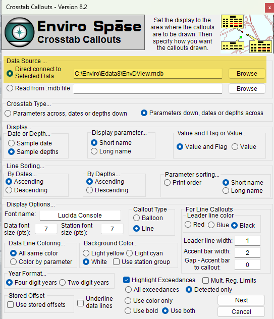
In the Corsstab Callouts form, make sure you choose the correct database used to share data between the Viewer and Enviro Spase 8. This database id EnvDView.MDB and should be located in the EData8\Database folder. Make sure you have not choosen the Viewer file which is EnvDDate8.ACCDB. This will be easier to located with file extensions on and not hidden. See graphic below with the incorrect folder and file path.